The World Painted
from € 75
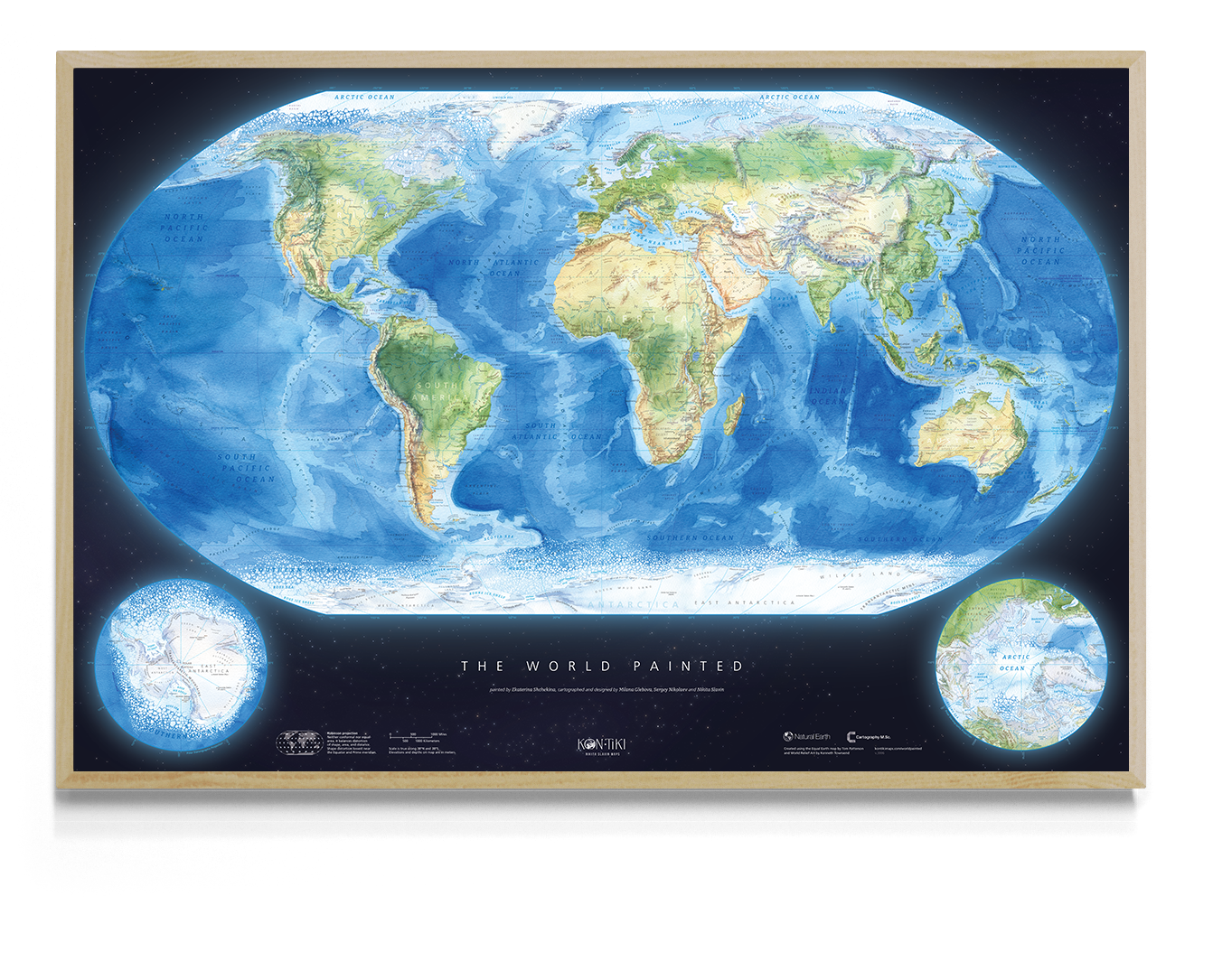
A physical world wall map with a hand-painted watercolour basemap and pioneering
cartographic design.
A labour of love, it is designed to be both beautiful and genuinely useful.
cartographic design.
A labour of love, it is designed to be both beautiful and genuinely useful.


A cartographer's dream

“One of the reasons I started this project was that when friends asked me,
‘Where can I find a good world map for my child or living room?’ - I didn’t have an answer.
We believe The World Painted can become a well-loved map for any setting.”
‘Where can I find a good world map for my child or living room?’ - I didn’t have an answer.
We believe The World Painted can become a well-loved map for any setting.”
Nikita Slavin 💙


“They were maps that lived, maps that one could study, frown over, and add to; maps, in short, that really meant something.”
To create a map like that — a map that lives,
that invites you to explore the world through it,
we painted the basemap by hand, then designed each layer one by one, blending the craft of classic cartography with the modern design tools power.
Every label was placed with care, every detail refined until the map felt clear, balanced, and
alive.
that invites you to explore the world through it,
we painted the basemap by hand, then designed each layer one by one, blending the craft of classic cartography with the modern design tools power.
Every label was placed with care, every detail refined until the map felt clear, balanced, and
alive.
Watercolour magic
The basemap is a true work of art - a watercolor rendering of nature that depicts mountains, plains, ocean floors, seas, and polar ice.
Multiple days of careful work went into it - the result is an image that’s not only beautiful but
also allows you to intuitively explore the landscape.
But remember, it’s more than just a picture. It’s a map built on accurate elevation and
landform data.
Multiple days of careful work went into it - the result is an image that’s not only beautiful but
also allows you to intuitively explore the landscape.
But remember, it’s more than just a picture. It’s a map built on accurate elevation and
landform data.
Failed to load OpenSeadragon. Please check your internet connection and refresh the page.
The fine details
The map presents the physical world with clarity and balance, free from noise and clutter. With over 2,000 carefully placed labels, it offers plenty for the geography nerd in all of us to
explore.
Don’t miss the detailing of the
🔎 sea ice — ice – solid where it remains year-round, scattered where it comes and goes.
explore.
Don’t miss the detailing of the
🔎 sea ice — ice – solid where it remains year-round, scattered where it comes and goes.
We chose 🔎 the Robinson projection to fit the globe onto a flat surface. The additional 🔎 polar insets make the high latitudes easy to read. Don’t miss the 🔎 research stations!
The whole map rests on a 🔎 starry backdrop — a quiet nod to the old maps where Earth floated on turtles.
The whole map rests on a 🔎 starry backdrop — a quiet nod to the old maps where Earth floated on turtles.
2051 labels on the main map, including:
— 426 settlements and polar stations 🏙️❄️
— 292 landforms ⛰️
— 254 rivers 🏞️
— 241 islands 🏝️
— 201 seas, oceans, straits, and bays 🌊
— 166 underwater features 🌊⬇️
— 152 mountain peaks 🏔️
— 80 lakes 🐟
— 50 deserts 🏜️
— 46 capes 🌬️
— 43 peninsulas 📍
— 38 regions 🗺️
— 23 coastlines 🧭
— 11 glaciers 🧊
— 11 salt flats 🧂
— 7 continents 🌍
— 6 lowlands 🌾
— 4 waterfalls 💦
plus 110 in Antarctica 🧊🇦🇶 and 194 in the Arctic ❄️🧭.
Reviews


Limited run of 50 prints.
Each one comes with a certificate of authenticity, hand-signed by the authors and individually numbered.
The map is produced on Hahnemühle German Etching — an archival-quality paper with a rich texture and gallery-grade finish.
By purchasing The Collector’s Print, you are not just buying a map – you are supporting independent cartography and helping bring our future cartographic projects to life.
€ 370
The Collector’s
Print
Comes unframed, rolled and safely packed in a cardboard tube.
A classic format that fits any interior.
A museum-quality Giclée print on Enhanced Matte Art — velvety smooth, heavyweight paper with deep colours and long-lasting quality.
taxes included.
Free Shipping with every order.
Free Shipping with every order.
The World Painted
Framed
With hanger
Rolled in tube
91x61cm
120x80 cm
Regular
Collector's Edition
€ 75
ORDER
Contacts

Without the best master's programme in the world, Cartography M.Sc., none of these wonders would have happened.


